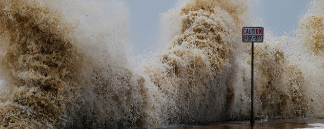
 Destructive water caused by Hurricane Ike in 2008. Photo by Scott Pena.
When you write a column five days a week, as I have done for more than seven years with the invaluable help of my colleague Amy Laburda, you get in the habit of saving interesting items for later use.
I keep a file of clips under the label “blog fodder.” One item that I put away more than a month ago was about an experimental product from the National Hurricane Center called the Prototype Storm Surge Watch/Warning Graphic. As a Floridian, I figured it would make a nice topic to explore sometime during this hurricane season, or perhaps right around the season’s end.
And then along came Hurricane Matthew.
You have probably never heard of a “storm surge watch” or a “storm surge warning,” because there has never officially been such a thing at the National Weather Service or its predecessor, the U.S. Weather Bureau. But wind-driven water is frequently the deadliest component of a tropical storm, and it is also the one most likely to catch people by surprise.
America’s deadliest hurricane was an unnamed storm that came ashore in Galveston, Texas, in September 1900. An estimated 8,000 to 12,000 people perished, most by drowning in the surge of 15 to 23 feet that accompanied that Category 4 storm.
The second-deadliest storm, which struck South Florida in 1928, also created most of its casualties by drowning. Remembered as the Okeechobee Hurricane, it killed at least 2,500 people by driving a wall of fresh water over the sides of Lake Okeechobee into the surrounding towns and farmland. A dike was later built to contain the lake against future storms.
And although it is remembered mainly for the inundation of New Orleans that followed the failure of the city’s levee system, Hurricane Katrina also drove a surge of water from the Gulf of Mexico as much as 28 feet deep and as far as a dozen miles from the coast. Very little in the path of that water survived, which contributed substantially to the storm’s $108 billion estimated property damage toll. Superstorm Sandy, an ex-hurricane, caused similar damage and took more than 100 lives in the United States, with drowning accounting for the largest number.
Storm surge can be as deceptive as it is deadly. When a hurricane makes landfall at the same time as high tide, the storm’s low barometric pressure can actually help lift water over beaches, dunes and protective structures at the same time winds of 75 miles an hour (or sometimes much more) are pushing water onshore. Large, battering waves usually ride on top of the elevated sea and cause even more destruction.
But surge does not have to come from the direction of the sea, as the Okeechobee Hurricane proved. Last week, Hurricane Matthew created significant flooding far up the freshwater St. Johns River in northern Florida, as well as along the Intracoastal Waterway in Marineland and other places. The storm’s winds piled water up at the mouth of the river and in the inlets through which the tides move into and out of the Intracoastal’s chain of rivers and canals, forcing water inland and preventing it from draining out again.
People who live along the beachfronts know perfectly well what a hurricane can do; they look at the ocean all the time. But people living out of sight of, and often a substantial distance from, the ocean may not appreciate the dangers. They often live in places that never flood – until one day, they do.
Many coastal flood maps have been updated in the wake of the big storms that have struck the country in the early 21st century. Aided by this data and by a growing appreciation of the threats, the National Weather Service’s hydrologists and other experts have built computer models that can predict the extent and depth of storm surge flooding, just as weather models have predicted storm tracks and wind speeds with increasing accuracy for many years.
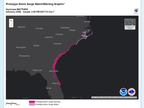 screenshot of the NHC Prototype Storm Surge Watch/Warning Graphic as of Oct. 7, 2016 - click to enlarge
The models are not perfect. In part, this is by design: The idea is to err on the side of caution, warning people who might be in harm’s way to relocate ahead of a storm, even if not every place in the warning area will actually experience flooding. This, too, follows the model of hurricane watches and warnings, which predict that hurricane conditions might occur (for a watch) or will occur (for a warning) someplace within the danger zone, even if those conditions do not occur at every place in that zone.
My wife and I own property near the beach in northern Florida’s Flagler County. We weren’t there when Matthew approached, and I would not have needed any official encouragement to leave the area ahead of the storm regardless. But quite a few of our neighbors only left when evacuations were ordered – not just on the seaward side of the Intracoastal, but also on the inland side in exposed areas near canals and other bodies of water.
I watched long-distance via webcams as the surge drove the Intracoastal’s water levels about five feet above normal at Marineland before the power failed all over the county and I lost sight of what was happening. Even at that point, it was obvious that significant floods were underway, and that it was a good thing most everyone on the barrier island had sought safety elsewhere.
I expect that by next year the surge watch and surge warning products will be part of the hurricane forecasters’ toolkit, and we will all soon be familiar with the terms. Thanks to technology and experience, it is a step forward whose time has arrived.


Posted by Larry M. Elkin, CPA, CFP®
Destructive water caused by Hurricane Ike in 2008. Photo by Scott Pena.
When you write a column five days a week, as I have done for more than seven years with the invaluable help of my colleague Amy Laburda, you get in the habit of saving interesting items for later use.
I keep a file of clips under the label “blog fodder.” One item that I put away more than a month ago was about an experimental product from the National Hurricane Center called the Prototype Storm Surge Watch/Warning Graphic. As a Floridian, I figured it would make a nice topic to explore sometime during this hurricane season, or perhaps right around the season’s end.
And then along came Hurricane Matthew.
You have probably never heard of a “storm surge watch” or a “storm surge warning,” because there has never officially been such a thing at the National Weather Service or its predecessor, the U.S. Weather Bureau. But wind-driven water is frequently the deadliest component of a tropical storm, and it is also the one most likely to catch people by surprise.
America’s deadliest hurricane was an unnamed storm that came ashore in Galveston, Texas, in September 1900. An estimated 8,000 to 12,000 people perished, most by drowning in the surge of 15 to 23 feet that accompanied that Category 4 storm.
The second-deadliest storm, which struck South Florida in 1928, also created most of its casualties by drowning. Remembered as the Okeechobee Hurricane, it killed at least 2,500 people by driving a wall of fresh water over the sides of Lake Okeechobee into the surrounding towns and farmland. A dike was later built to contain the lake against future storms.
And although it is remembered mainly for the inundation of New Orleans that followed the failure of the city’s levee system, Hurricane Katrina also drove a surge of water from the Gulf of Mexico as much as 28 feet deep and as far as a dozen miles from the coast. Very little in the path of that water survived, which contributed substantially to the storm’s $108 billion estimated property damage toll. Superstorm Sandy, an ex-hurricane, caused similar damage and took more than 100 lives in the United States, with drowning accounting for the largest number.
Storm surge can be as deceptive as it is deadly. When a hurricane makes landfall at the same time as high tide, the storm’s low barometric pressure can actually help lift water over beaches, dunes and protective structures at the same time winds of 75 miles an hour (or sometimes much more) are pushing water onshore. Large, battering waves usually ride on top of the elevated sea and cause even more destruction.
But surge does not have to come from the direction of the sea, as the Okeechobee Hurricane proved. Last week, Hurricane Matthew created significant flooding far up the freshwater St. Johns River in northern Florida, as well as along the Intracoastal Waterway in Marineland and other places. The storm’s winds piled water up at the mouth of the river and in the inlets through which the tides move into and out of the Intracoastal’s chain of rivers and canals, forcing water inland and preventing it from draining out again.
People who live along the beachfronts know perfectly well what a hurricane can do; they look at the ocean all the time. But people living out of sight of, and often a substantial distance from, the ocean may not appreciate the dangers. They often live in places that never flood – until one day, they do.
Many coastal flood maps have been updated in the wake of the big storms that have struck the country in the early 21st century. Aided by this data and by a growing appreciation of the threats, the National Weather Service’s hydrologists and other experts have built computer models that can predict the extent and depth of storm surge flooding, just as weather models have predicted storm tracks and wind speeds with increasing accuracy for many years.
screenshot of the NHC Prototype Storm Surge Watch/Warning Graphic as of Oct. 7, 2016 - click to enlarge
The models are not perfect. In part, this is by design: The idea is to err on the side of caution, warning people who might be in harm’s way to relocate ahead of a storm, even if not every place in the warning area will actually experience flooding. This, too, follows the model of hurricane watches and warnings, which predict that hurricane conditions might occur (for a watch) or will occur (for a warning) someplace within the danger zone, even if those conditions do not occur at every place in that zone.
My wife and I own property near the beach in northern Florida’s Flagler County. We weren’t there when Matthew approached, and I would not have needed any official encouragement to leave the area ahead of the storm regardless. But quite a few of our neighbors only left when evacuations were ordered – not just on the seaward side of the Intracoastal, but also on the inland side in exposed areas near canals and other bodies of water.
I watched long-distance via webcams as the surge drove the Intracoastal’s water levels about five feet above normal at Marineland before the power failed all over the county and I lost sight of what was happening. Even at that point, it was obvious that significant floods were underway, and that it was a good thing most everyone on the barrier island had sought safety elsewhere.
I expect that by next year the surge watch and surge warning products will be part of the hurricane forecasters’ toolkit, and we will all soon be familiar with the terms. Thanks to technology and experience, it is a step forward whose time has arrived.
Related posts:
No related posts.